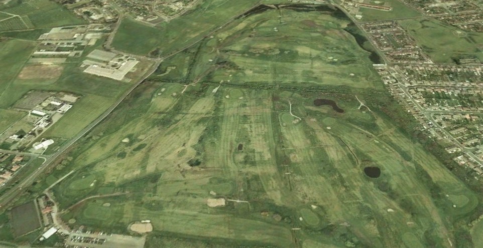
Bootle Golf Course From The Air pre 1950s

Post your photo's and video memories about Bootle here...
User avatar
Bonesy
Posts: 3475
Joined: Mon Dec 29, 2008 2:05 pm
Location: Lydiate

User avatar
BOBHAMO
Posts: 5935
Joined: Sat Aug 04, 2007 12:20 pm
Location: BIG CITY

Like it Keith :D :D no strand park or ford estate :D :D
looks like no dunnings bridge road

bobhamo
bootle born altcar road
User avatar
Bonesy
Posts: 3475
Joined: Mon Dec 29, 2008 2:05 pm
Location: Lydiate

Dunnings, Bob when whould that have been built. You can see my old school Strerrix Ln but in this photo I think it will still have been an army camp. Boundry and Sterrix Lns can bee seen and the golf clubhouse. No English Electric either.
Cheers Bob.


Keith
User avatar
Bonesy
Posts: 3475
Joined: Mon Dec 29, 2008 2:05 pm
Location: Lydiate

also can make out the allotments corner of Dunnings and Netherton Way also the Netherton pub.


Keith
User avatar
BOBHAMO
Posts: 5935
Joined: Sat Aug 04, 2007 12:20 pm
Location: BIG CITY

Remember the old huts as a school , going the golf ponds of the footpath
think the ford estate was built 1954 as a kid thought ford was so far away
going my uncle jacks behind the big mound tristams croft
bobhamo
bootle born altcar road
User avatar
ALAMO2008
Posts: 1014
Joined: Wed Jan 07, 2015 2:31 pm
Location: Aberystwyth

My old Primary school - Sterrix Lane is centre of picture, cheers for that.

We moved from 134 Bedford Road into our new Council House at 12 Randall Drive, Ford, off Sterrix Ave off Sterrix Lane and Convent on 6th March 1953
I was nearly 4 years old then.
User avatar
Invicta
Posts: 2749
Joined: Wed Sep 02, 2015 6:46 pm
Location: Garden of England

No school nor first married house on Barnfield Close. I can't see the ponds or should I go to "Specsavers" ? :D ken
User avatar
BOBHAMO
Posts: 5935
Joined: Sat Aug 04, 2007 12:20 pm
Location: BIG CITY

Image
BOBHAMO
bootle born altcar road
PeterR
Posts: 232
Joined: Tue Apr 27, 2010 1:16 pm
Location: Evandale Tasmania

Bonsey, a very interesting picture of the golf course and surrounding Bootle area, I would suggest this view was taken pre war (Early 30s)
What appear as "Ponds" on the golf course are bunkers , Dunning Bridge Rd (We used to call the NEW rd) hasn't been built in this view, the foresight of Threlfalls has to be admired building the "The Netherton" way out in the country as it was then -the war put a stop to all the great plans to take Bootle out that way, English Electric was built about 46-47 and was called "The Jet"--and on the Big estate (Galsworthy ave area)_ was between the top of Harris drive and "The Pleasure" vacant land we used to play there on our bikes, there was a great big crater were a land mine had dropped, the last time I was there about 1962 a couple of shops had been built. Also (Just remembered ,On the road as you came off Ford Station bridge towards "The Netherton" were the THEN rd veared off to the left , there WAS two sandstone gateposts (about the middle of the pleasure pavilion )-so in the early days this would have been a farm gate.
Cheers
Peter
Born in Spenser Street
User avatar
BOBHAMO
Posts: 5935
Joined: Sat Aug 04, 2007 12:20 pm
Location: BIG CITY

Image
Peter on the photo i put the ponds on the place they where i fished them early 50s
they are the original farm ponds if you look on the map there where lots on the golf course
the 2 sandstone posts could have been off the captains house where captains lane gets its name
bobhamo
bootle born altcar road
User avatar
BossHogg
Posts: 572
Joined: Thu Mar 24, 2016 4:19 am
Location: Netherton, Maryport.
Contact:

I lived on Sterrix Lane from 1982-1997, I was away for 7 years during that time serving in the army. :wink:
PeterR
Posts: 232
Joined: Tue Apr 27, 2010 1:16 pm
Location: Evandale Tasmania

Thanks Bob, I never played The Bootle golf course and have since looked at the map and thought WOW that's a lot of bunkers, as kids we used to sneak in looking for golf balls. Interesting map You have put on showing the "Captains House" -I didn't know about that-Who was "The Captain' ? do You know ? . I see the Swifts lane bridge on the map-We used to swim in the canal there.
Regards
Peter R
Born in Spenser Street
User avatar
Invicta
Posts: 2749
Joined: Wed Sep 02, 2015 6:46 pm
Location: Garden of England

The ponds (2) were to the right of the cinder path going from Ford/Litherland end to Netherton. We also used to fish there after hours but spent most of the time fishing for balls which we'd flog to the golfers next day. :D Ken
User avatar
BOBHAMO
Posts: 5935
Joined: Sat Aug 04, 2007 12:20 pm
Location: BIG CITY

K en the fun we had cycleing to the ponds with a home made bamboo rod and quill and line float bought at
broadway stores :D :D :D
we used to go at first light then got off when the golfers came :D :D
like yourself a wire basket on a rope getting the golf balls :D :D :D
when i lived in ford my kids went to the holy ghost
and i took my eldest lad bob to the ponds when he was about seven
and he caught his first perch :D :D :D
Peter the land was called captains farm . i liked living there one of my local pubs stand park :D :D
then moved to liverpool ,big city :D :D :D
i still go back now and again only one cousin left john who still lives there

bobhamo
bootle born altcar road
User avatar
Invicta
Posts: 2749
Joined: Wed Sep 02, 2015 6:46 pm
Location: Garden of England

One night eager to get there Bob, I got my rod caught in the spokes of my bike. Head first over the handle bars, still got gravel ( cinders) around my elbows today. That was on the path from The Stand to the Army Huts running by the Greenie.
Happy days in what was still countryside at that time. :D Ken
User avatar
BOBHAMO
Posts: 5935
Joined: Sat Aug 04, 2007 12:20 pm
Location: BIG CITY

Ken it was the country side to us :D :D
Image
bobhamo
bootle born altcar road
User avatar
marknjen
Posts: 527
Joined: Sat Oct 17, 2009 7:06 pm
Location: bootle

Image

Thought this may help too?
User avatar
Dan
Posts: 4730
Joined: Sat Jul 07, 2018 6:24 pm

From the Bootle Times 1974.

Image

Regards

Dan
User avatar
Dan
Posts: 4730
Joined: Sat Jul 07, 2018 6:24 pm

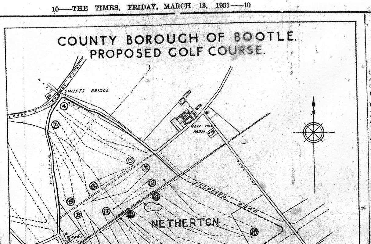
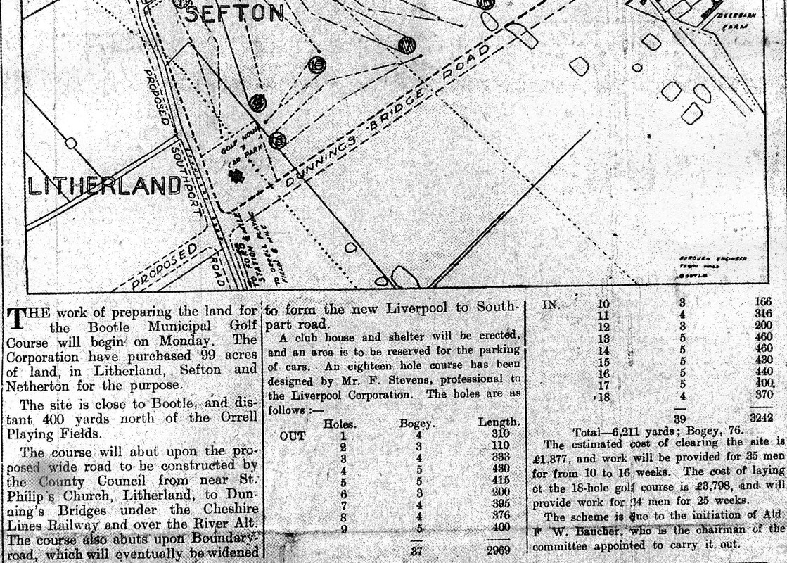
Proposed layout of the golf course. I didn't realise the Southport Road proposal had been around for so long.
Also Swift's Lane never made it to the Park Lane/Dunnings Bridge junction.
New Park Farm stood on (Brown's Lane)-correction Bridge Lane. .
I guess the irregular forms on the map were ponds.

Image
Image

Regards

Dan
Last edited by Dan on Sat Mar 23, 2019 9:08 am, edited 1 time in total.
Bri
Posts: 99
Joined: Sun Mar 27, 2011 9:35 pm
Location: Netherton

New Park Farm still stands on Bridge Lane, the proposed road never went right through.
User avatar
Dan
Posts: 4730
Joined: Sat Jul 07, 2018 6:24 pm

Bri wrote:New Park Farm still stands on Bridge Lane, the proposed road never went right through.

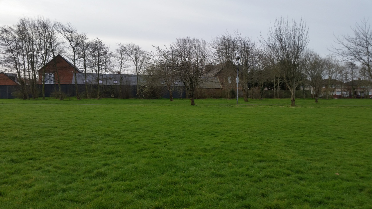
Photo taken this morning from the old Bootle Grammar School grounds, now Marian Park.
The old farmhouse is on the right, to the left new build completed in the last few months.

Image

Regards

Dan
PeteH
Posts: 17
Joined: Tue Apr 16, 2019 8:15 pm

Hi

The original photo in this thread wsa taken in 1936. There are collection of them on the 'Britain from above' website https://britainfromabove.org.uk/search? ... d&year=all

Would be delighted if someone could spot Bark Road on there!
User avatar
filsgreen
Posts: 3412
Joined: Sun May 12, 2013 8:28 am

Hi Pete, welcome to the forum. :D
User avatar
Dan
Posts: 4730
Joined: Sat Jul 07, 2018 6:24 pm

Bark Road, Litherland.

Image

Regards

Dan
User avatar
BOBHAMO
Posts: 5935
Joined: Sat Aug 04, 2007 12:20 pm
Location: BIG CITY

Welcome Pete :D
Image
st philips with the marker
click to enlarge bark road
bobhamo
bootle born altcar road
PeteH
Posts: 17
Joined: Tue Apr 16, 2019 8:15 pm

Thanks Lads, that's very helpful, and thanks for the welcome - great site, I'm really enjoying working my way through it.

My dad (Bill Halsall) lived in 33 Bark Road in the 1930s as a teenager and then moved to a new house, 21 Kirkstone Road just in time for WW2. Comparing your images with the original view from the air in 1936 it seems to me that Bark Road may only have been partially built at the time, or perhaps not yet underway. I know that when they moved into Kirkstone Road building work stopped because of the war and most of the houses existed only as a few inches of foundation showing the layout / floor plan. The girls in the family used these to 'play house', make picnics with whatever they could lay their hands on..

Another photo in the Britain from Above series shows a little more of the view to the right https://britainfromabove.org.uk/en/image/EPW050649

You can see what the area looked like in 1939 on this map https://maps.nls.uk/view/126522107. There is a pond on a field boundary just North East of the Diamond Works Sports ground which you can also see in the ariel view, I found that a useful point of reference. The map shows Bark Road and the first part of Kirkstone Road completed by the onset of war so I guess a lot of building took place between 1936 and 1939. The fields all have a reference number on the map, the figure below indicating the size in acres. It seems that plot 94 has just a few houses in at the time of the photograph (unless there are more out of sight).

33 Bark Road was on the Northern side of the road and the back gardens at the time backed onto the open field 'recreation ground' that you can see in both the photo and the map. I think it must have been rough grazing as occasionally a cow would lean its head over the back garden fence. So much more rural than today.

I particularly like the view of the convent in the ariel photo. I have only yet found one image of it and it is now demolished. My dad and his brothers were altar boys there. Id love to know more about about it, but little seems documented.

Cheers

Pete
User avatar
Dan
Posts: 4730
Joined: Sat Jul 07, 2018 6:24 pm

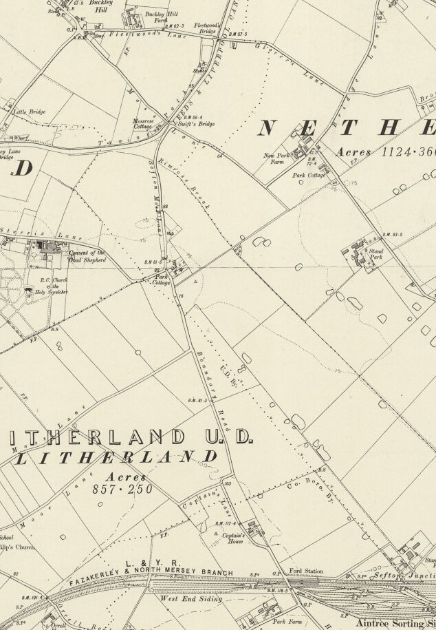
Bit of the Ordinance Survey map, revised 1938, published 1947.

Image

Regards

Dan
User avatar
BOBHAMO
Posts: 5935
Joined: Sat Aug 04, 2007 12:20 pm
Location: BIG CITY

Image
1938
Image
1949
Image
bobhamo
bootle born altcar road
PeteH
Posts: 17
Joined: Tue Apr 16, 2019 8:15 pm

Wow!

Thanks Dan and bobhamo. A lot more help there than I expected. The list of names of their neighbours in each of those roads is really interesting, especially as it gives their occupations as well. Might trigger some memories with the one surviving sibling of that family.
The name 'Bradley Road' at the top of the list caught my eye as well. Just around the corner to Bark Road of course, but the Alty family lived there (don't know the number), cousins of the Halsall family. Their daughter Margaret Ellen Alty was killed on May 4th 1941 when a bomb hit the shelter. Four other people killed there too.
Is the last photo the convent? If so its a very rare picture indeed.

Thanks again and much appreciated,

Pete
User avatar
Dan
Posts: 4730
Joined: Sat Jul 07, 2018 6:24 pm

Image
Image

The opening of the course had been put back a few months, because the original pavillion which had been completed, fitted out and inspected by several council commitee members, burnt to the ground.

Regards

Dan
henry
Posts: 1869
Joined: Tue Mar 21, 2006 6:45 pm

My sister ANNIE lived in the house on the golf course with her husband JoeO Sullivan who was the leading Groundsman and looked after the course and also overseen all the parks in sefton
HENRY BORN FLORIDA STREET OFF STRAND ROAD
JLEADY
Posts: 2
Joined: Mon Mar 16, 2009 9:12 pm
Location: bootle

Dan wrote: Tue Apr 30, 2019 2:27 pm Image
Image

The opening of the course had been put back a few months, because the original pavillion which had been completed, fitted out and inspected by several council commitee members, burnt to the ground.

Regards

Dan
Brilliant find Dan!
User avatar
Dan
Posts: 4730
Joined: Sat Jul 07, 2018 6:24 pm

Image

The picture is of the golfy from above the Dunningsbridge Road end.

It is pre-2009 as the Hugh Baird South Campus,adjacent to the Stand Park, hadn't yet been built.

You can make out Netherton Moss to the upper right.

Marian Gardens, where Bootle Grammar School for Boys stood.

Moss Lane, Sterrix Lane, Swifts Lane, Bridge Lane, Sarah's Croft, Kenneth Close, Columban Close.
User avatar
Invicta
Posts: 2749
Joined: Wed Sep 02, 2015 6:46 pm
Location: Garden of England

Our first house was in Barnfield Close which would be bottom right but not sure it’s visible. K
User avatar
Dan
Posts: 4730
Joined: Sat Jul 07, 2018 6:24 pm

Found this on Golf Magic.

If it did happen, it must have been only once or twice. It's not something you'd forget to mention.

Bob Warters
Fri, 29 Mar 2013
Image

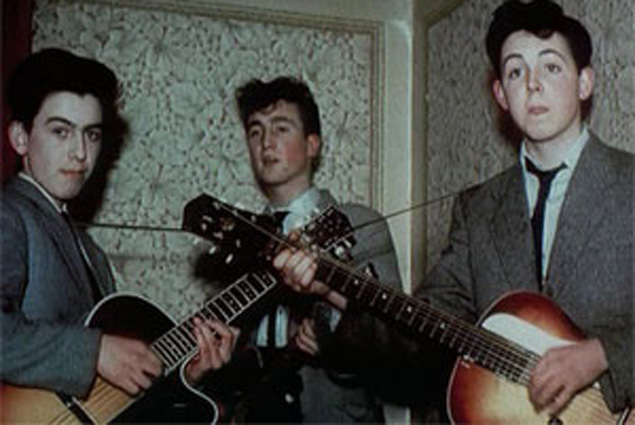
Harrison (left), Lennon (middle) and McCartney (right) used to loop to raise money for instruments

Last week marked the 50th anniversary of the release of The Beatles’ multi-million selling debut album ‘Please, Please Me’.

You may already know that.

What you might not know, however, is that three of the Fab Four – Paul McCartney, John Lennon and George Harrison – sometimes caddied to help fund the instruments they bought to play on that first record.

Bootle municipal golf course, built in 1934, was just a few miles from their homes in North Liverpool and, although there’s no record of any of them playing golf, the trio reputedly saw the opportunity to earn some pocket money offering to carry the clubs of local golfers round the parkland course.

Whatever money they scraped together was used as a down payment on various guitars they acquired from Hessy’s Music Store in the city where many Merseyside musicians knew they could get credit on their purchases.

They told the owners that one day they would be famous and they’d pay them back.

Yeah, yeah right!
Post Reply