
pre war Bootle map
-
rivermersey
- Posts: 235
- Joined: Mon Nov 26, 2007 12:27 am
- Location: Bootle
Thanks Emma.
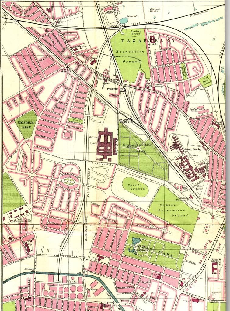
How much of the Bootle area does your map show?
How much of the Bootle area does your map show?
Born in Bootle 1960 lived on Bailey Drive then the old roan.
-
BOBHAMO

- Posts: 5935
- Joined: Sat Aug 04, 2007 12:20 pm
- Location: BIG CITY
nice to see the map in colour emme , if any of are bootle bucks need to buy 1900 ordinance maps the best are the godfrey edition , they cover all liverpool , bootle , crosby , seaforth antree, i have about 20 , they cost about £2 .50 ,and can be bought in most book shops in town , these show all streets m parks , factories there are 3 on bootle , they are worth buying, bobhamo
-
PETER CRAIG
- Posts: 2545
- Joined: Sun Aug 27, 2006 8:24 pm
- Location: BOOTLE
-
rivermersey
- Posts: 235
- Joined: Mon Nov 26, 2007 12:27 am
- Location: Bootle
Hi Emma
Bailey drive area if it's on the map please.
Thanks
Bailey drive area if it's on the map please.
Thanks
Born in Bootle 1960 lived on Bailey Drive then the old roan.
-
Bernie R

- Posts: 5639
- Joined: Thu Jan 10, 2008 9:30 am
- Location: Netherton
Thanks for posting that Emma.
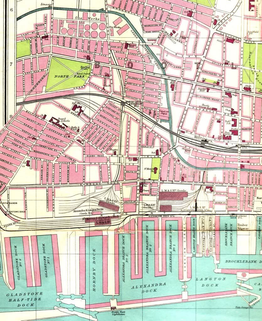
Amzing to see where Southport Road and Brewster Street finished so far apart before they became joined up later.
Can also spot good old Romeo Street in the bottom right just to the left of Bankhall Station.
Just to the right of Marsh Lane Station, we can see Boston Street - what were the names of those two streets that come down from it (can't read them on the screen) - these are just in the vicinity of where my flat in Jersey Close was (late 70s/early 80s).
Bern
Born and raised in Romeo Street, later Lambeth Walk, Jersey Close, Garden Place, Hawthorne Rd, Gonville Rd now Netherton

-
emma
- Posts: 190
- Joined: Fri Apr 25, 2008 10:27 pm
- Location: New Zealand
Yes, I agree Bob, the Old Ordinance Survey Maps are a great resource, I have quite a few myself and not just of Liverpool. I use them a lot in my family history research.BOBHAMO wrote:nice to see the map in colour emme , if any of are bootle bucks need to buy 1900 ordinance maps the best are the godfrey bootle , they are worth buying, bobhamo
-
emma
- Posts: 190
- Joined: Fri Apr 25, 2008 10:27 pm
- Location: New Zealand
Here's another portion of map - Peter asked for Southport Road? Also, Rivermersey requested Bailey Dr - sorry,this is as far as the map goes in Orrell - the map does not have a date but I am guessing it's the late 20s early 30s - the "Kingsway"Tunnel is on there and that was underway in late 20s and opened 1933. I think the area around Bailey Dr was still being built then and there has already been a old photo put on site of the area in 1933 and it looks like it was pretty new then. I lived in Bailey Dr area 1944-1957.
My old map was published by Bartholomews and printed on linen and sold for 3/6d - probably quite expensive for the time.
My old map was published by Bartholomews and printed on linen and sold for 3/6d - probably quite expensive for the time.
Last edited by emma on Sun May 03, 2009 12:43 am, edited 1 time in total.
-
PETER CRAIG
- Posts: 2545
- Joined: Sun Aug 27, 2006 8:24 pm
- Location: BOOTLE
-
Jimboy
- Posts: 43
- Joined: Thu Jan 04, 2007 4:53 am
- Location: Australia
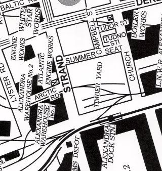
Thanks for that,Emma.For years I have been trying to find a Bootle map that showed my home street there(Tudno St off Church St opposite Alexandra Dock.It,along with Summer Seat, Tudor St,and most of Campbell St were demolished in Bootle's "renewal" phase after surviving the bombing of WW2 and all.  .
.
Lived in Tudno St Bootle,now in Newcastle,Oz
-
daveowe
- Posts: 778
- Joined: Wed Oct 24, 2007 7:49 pm
- Location: Transient
Hi Emma
Your dating of the map late 1920s is a good estimate a couple of clues I can offer. Walton Hospital site is still identified as the West Derby Union, Workhouse, the workhouse system was abolished April 1930. The Carlton Cinema Orrell Park, site is Victoria Park, cinema was opened Sept 1930.
Dave
Your dating of the map late 1920s is a good estimate a couple of clues I can offer. Walton Hospital site is still identified as the West Derby Union, Workhouse, the workhouse system was abolished April 1930. The Carlton Cinema Orrell Park, site is Victoria Park, cinema was opened Sept 1930.
Dave
-
Alfie
- Posts: 4
- Joined: Wed Mar 25, 2009 4:58 am
- Location: Toronto Canada
Dear Emma, finally, a map of Tudno Street and surrounding area. It means an awful lot to be able to look at the map, brings back a whole lot of very good memories of my youth in good old Bootle.Many thanks from Toronto Canada.-----Alfie.
-
Barby
- Posts: 343
- Joined: Fri Mar 23, 2007 10:24 am
- Location: Christchurch, New Zealand
Would Flint Street, Bootle, be in any areas of the maps that have been loaded to the site.
My mother was born at Flint Street in 1921.
Would love to see roughly the area she was born in.
Many thanks.
Barby
My mother was born at Flint Street in 1921.
Would love to see roughly the area she was born in.
Many thanks.
Barby
Looking for, Evans, Keatinge, Porter, Anderson, Norton, Lobb, families
-
carolmcb
- Posts: 144
- Joined: Tue Apr 25, 2006 10:57 pm
- Location: Born in St Johns Rd, Bootle, living in Norfolk! :-(
hi Emma, love the photo you have there, it's mount Cook isn't it? My brother lives in NZ, he's down in Invercargill. I've been twice to stay with him and loved it over there.
How do you get the photo up there? I can see any access to the avators either.
How do you get the photo up there? I can see any access to the avators either.
REID, ROBERTS, STAINES, BRAWN, HARDY, WILLIAMS, GRIFFITHS, DELANEY, CUDDY, SMITH, BYRNE, LUCAS, HEGARTY, HARVEY
-
emma
- Posts: 190
- Joined: Fri Apr 25, 2008 10:27 pm
- Location: New Zealand
Hi Carol
no, that's Mitre Peak reflected in Milford Sound. You will find facility for an Avatar if you go to your "profile" page and scroll down to the end. But take a look at the instructions "How to Post photos on our Bootle Forum" first at the top of this forum.
You wouldn't like it down here just now as it is very cold as we head into winter brrrrr
-
Barby
- Posts: 343
- Joined: Fri Mar 23, 2007 10:24 am
- Location: Christchurch, New Zealand
Dave,
Thanks will take a look, great to be able to have these maps to see where our family lived.
Emma, Yes, it will be VERY cold down there at the moment, don't envy you at all, was pretty cold here in Christchurch yesterday too.
Sun shining at the moment so should be a great day.
Have a good one everyone.
Take care.
Barby
Looking for, Evans, Keatinge, Porter, Anderson, Norton, Lobb, families
-
carolmcb
- Posts: 144
- Joined: Tue Apr 25, 2006 10:57 pm
- Location: Born in St Johns Rd, Bootle, living in Norfolk! :-(
Hi Emma, of course it's Mitre Peak, sorry about that, my mistake. My brother took me on a boat trip some years back and I found Milford Sound absolutely breathtaking. I've got photos somewhere of us on the boat with that view in the background! He also took me down the glow-worm caves (though he had no idea I'm claustrophobic and I had a panic attack whilst in there). We went down in the underwater observatory too which was also fascinating.emma wrote:Hi Carol no, that's Mitre Peak reflected in Milford Sound. You will find facility for an Avatar if you go to your "profile" page and scroll down to the end. But take a look at the instructions "How to Post photos on our Bootle Forum" first at the top of this forum.
You wouldn't like it down here just now as it is very cold as we head into winter brrrrr
I know what you mean about the weather, it can be extremely cold, can't it. I've done two trips over there and on my 2nd the weather was so wet and cold that I had 2 radiators on in the bedroom to try to keep warm. Still, it's such a beautiful country I was quite happy to wrap up warm for my stay.
Re Avator - I've checked that out and on my profile page I see the avator section at the bottom BUT, for some reason it doesn't give me access to it. I'll have another look. Thanks for your help!
REID, ROBERTS, STAINES, BRAWN, HARDY, WILLIAMS, GRIFFITHS, DELANEY, CUDDY, SMITH, BYRNE, LUCAS, HEGARTY, HARVEY
-
Michael Williams
- Posts: 13
- Joined: Thu Sep 04, 2008 10:23 pm
- Location: gloucester
Fabulous map, pity you can't still buy them... but does anyone know the location of York St, I always believed it was at the back of Strand Road somewhere, my rellies lived there eons ago.
-
rockanrollagain
Emma interesting map I notice that on your first one Miranda Rd runs from Wadham right through to Balliol... I only know it as stopping at Wadham. Can anyone shed any light ? Did Miranda Road run right through the park to Balliol road?, if so they should re-name the path Miranda Way.
Has anyone got any old pics of days gone by in Kings park? I remember when the paddling pool was open and we went for picnics and a whole day out.
Has anyone got any old pics of days gone by in Kings park? I remember when the paddling pool was open and we went for picnics and a whole day out.
-
john j connell
- Posts: 1249
- Joined: Fri Mar 27, 2009 11:18 pm
- Location: The Fourth Grace.
Emma,are your maps taken from Bartholomew's pocket Atlas and Guide to Liverpool 1928 priced at one shilling,if so, i have the same book. It is good isn't it.~~~~~jjc
-
rockanrollagain
Yes, Emma now you mention it South Park Way sounds right. Do you have any old ones of the Bailey Drive area?
-
rockanrollagain
Hello Emma, no just curious as to what was there before the houses were built aprox 1927?