Hi Paula
on my map there are a few of the main streets laid out such as Moss Lane,Alexandra Dr, Albert Dr surrounding an area called Victoria Park. Maybe someone has a map earlier than this one with more detail. I'd like to know too as I grew up in the area.
pre war Bootle map
-
sfox132
- Posts: 2
- Joined: Wed Aug 25, 2010 11:12 pm
Can any one show me where Elm Street and Pleasant Grove were on the old maps? I understand that they must have been near Derby Road and when the road was widened they disappeared. My grandmother also told me that her grandparents home at 16 Elm St was destroyed during the bombing of Bootle and when she went to visit England n the late 70's or early 80's it had not been rebuilt?
Thanks
Thanks
-
lily8
- Posts: 10062
- Joined: Tue Aug 07, 2007 8:57 am
- Location: Far North Queensland Australia
Hi Martin  here is an old post re Elm Street may help????
http://www.bootlehistory.com/forum/view ... 9319675cb5
http://www.bootlehistory.com/forum/view ... 9319675cb5
Lily
-
oriel55
- Posts: 179
- Joined: Sat May 19, 2007 8:31 pm
- Location: Romentino, (No), Italia
York Road.
From Strand Road go down Washington Street (entrance opposite Jersey Street), first Road on the left is York Street; it is a dead-end/cul-de-sac as the end of the street backs onto the railway line (Liverpool - Southport).
From Strand Road go down Washington Street (entrance opposite Jersey Street), first Road on the left is York Street; it is a dead-end/cul-de-sac as the end of the street backs onto the railway line (Liverpool - Southport).
-
bynbrig
- Posts: 219
- Joined: Sun Jul 18, 2010 3:55 pm
- Location: Bath, somerset
Brilliant Emma!
Just found Hemer Terrace on it! Can't believe how close it was to the Gladstone Docks.
My Craven ancestors had a Wine and Spirit merchant warehouse/shop there about 1870.
Just fascinated as to how it all looked, in that age, but looking at the maps makes it,
Many thanks!!
Sue
Just found Hemer Terrace on it! Can't believe how close it was to the Gladstone Docks.
My Craven ancestors had a Wine and Spirit merchant warehouse/shop there about 1870.
Just fascinated as to how it all looked, in that age, but looking at the maps makes it,
Many thanks!!
Sue
Bootle parents, brought up in Litherland, watching bowls played at the White house Pub
-
Ritchiegrandchild
- Posts: 6
- Joined: Fri Aug 21, 2020 1:57 pm
Hi, My Mum was Julia Ritchie b. 18/1/1921 who came from Bootle. Her parents were Alfred and Mary Ritchie who lived most of their married life in Tudor Street. I wonder if you could help me find the area where she was born and raised. I'd love to see a map. From the 1911 Census, her family lived in 57, Teulon Street. On my grandparents' marriage certificate (1902) their addresses were given as 52 Gill Street and 115 Canterbury Street. Then on my Mum's birth certificate her parents' address is given as 4 Tudor Street. I also know from a cousin of mine (Alfie Beisty that some family members also lived in Tudno Street which was very close, I believe.


-
Dan

- Posts: 4730
- Joined: Sat Jul 07, 2018 6:24 pm
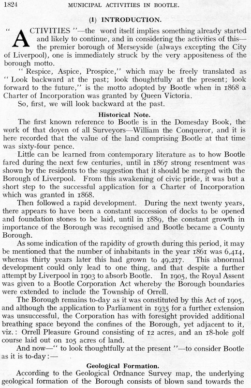
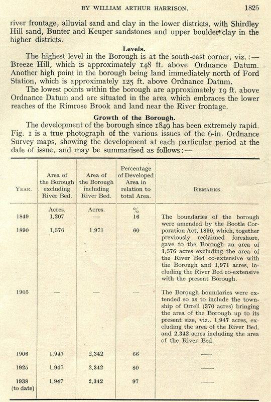
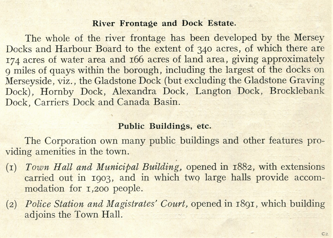
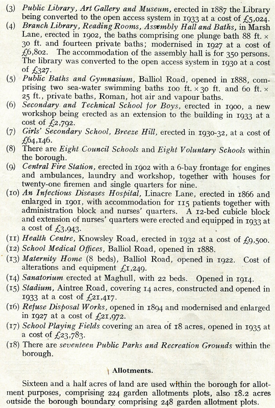
I thought I'd put the introduction to the April1938 meeting of the municipal and county engineers here.
Where there are already threads for topics, such as the golf course or Orrell Pleasure, I'll add to those threads.
At the time of the meeting Bootle's Borough Engineer & Surveyor was William Arthur Harrison.
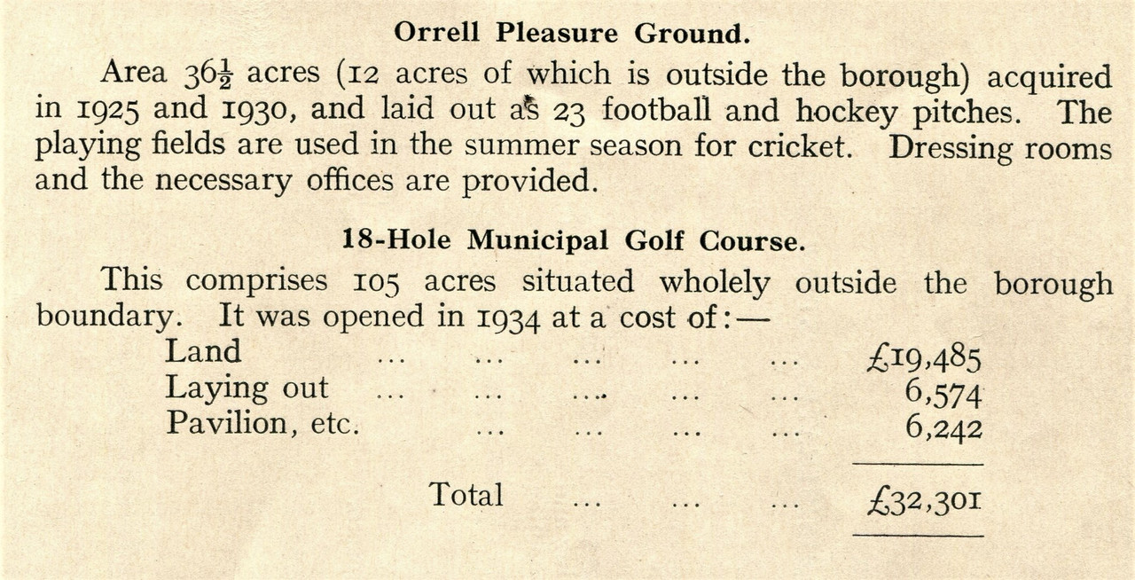
Where there are already threads for topics, such as the golf course or Orrell Pleasure, I'll add to those threads.
At the time of the meeting Bootle's Borough Engineer & Surveyor was William Arthur Harrison.
-
Byrne
- Posts: 7
- Joined: Wed Jan 18, 2023 12:01 am
Heya BobBOBHAMO wrote: ↑Sat May 02, 2009 10:00 am nice to see the map in colour emme , if any of are bootle bucks need to buy 1900 ordinance maps the best are the godfrey edition , they cover all liverpool , bootle , crosby , seaforth antree, i have about 20 , they cost about £2 .50 ,and can be bought in most book shops in town , these show all streets m parks , factories there are 3 on bootle , they are worth buying, bobhamo
Do you know if Boreland Rd/St was lost during the bombings & it appears when Bootle was rebuilt they didn't restore the name Boreland to any of the roads?
-
BOBHAMO

- Posts: 5935
- Joined: Sat Aug 04, 2007 12:20 pm
- Location: BIG CITY

Hi Byrne
The photo is marsh lane after the war
Boreland st is the one with the dot
all the houses where there upto early 60s i remember them
the street directories some times miss streets
and the later ones 1938 /52/ 62/ dont show Boreland st
it was built 1881
bobhamo
bootle born altcar road