History of ‘Cambridge’ streets: Sidney rd, Gonville rd, Downing rd, Clare rd?
-
Charlie Lo
- Posts: 10
- Joined: Thu Nov 19, 2020 8:19 pm
Can anybody please help with the history of houses built along Sidney, Gonville, Clare and Downing roads? I guess they were built as part of the same development and I’m trying to find out when (what year) they were built; who was the landlord; what were the amounts of rent; and, did they have inside toilets when first built (I remember the house I lived in as a kid had an outside lavvie as well at the one in bathroom upstairs)? Thank you.
-
Dan

- Posts: 4730
- Joined: Sat Jul 07, 2018 6:24 pm
Gonville Road in Bootle
Good evening Charlie.
The most important fact regarding the history of Gonville Road is: I was born there in June 1953.
Some less important stuff below. I'll see if I can find anything else.
Gonville Road is a Street in the Merseyside town of Bootle and measures approximately 354 metres long.
The average house in Gonville Road sells for £68,310.53
There are 3 other streets named Gonville Road in Great Britain.
Gonville Road is within the area of Sefton District (B) Council who provide services such as refuse collection and are responsible for the
collection of council tax .
Gonville Road has been given the Unique Street Reference Number of 34101159 in the National Street Gazetteer.
The average elevation of Gonville Road is roughly 36.15 metres above sea level. with the highest point being 39.90 and the lowest point
being 33.00. A change of 6.90 metres.
Average House Prices for Gonville Road
Year Sales Average House Price
2019 2 £70,000.
2018 7 £70,200.
2017 3 £76,667.
2016 4 £59,250.
2015 3 £66,500.
Gonville Road has the postcodes of L20 9LN, L20 9LP, L20 9LR and L20 9LW.
Gonville Road is located within the county of Merseyside which is in the North West (England) region of the UK. 181.02 miles North West
from the centre of London, 2.73 miles North from the centre of Liverpool, 18.04 miles North from the centre of Chester and 30.47 miles
West from the centre of Manchester.
Map of Gonville Road
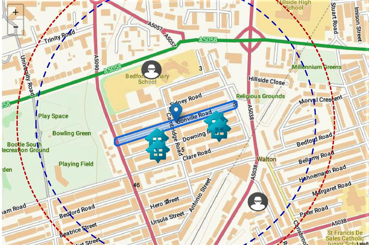
Walking Distances
Blue Circle = 5 Minutes Walk (400 metres)
Green Circle = 10 Minutes Walk (800 metres)
Good evening Charlie.
The most important fact regarding the history of Gonville Road is: I was born there in June 1953.
Some less important stuff below. I'll see if I can find anything else.
Gonville Road is a Street in the Merseyside town of Bootle and measures approximately 354 metres long.
The average house in Gonville Road sells for £68,310.53
There are 3 other streets named Gonville Road in Great Britain.
Gonville Road is within the area of Sefton District (B) Council who provide services such as refuse collection and are responsible for the
collection of council tax .
Gonville Road has been given the Unique Street Reference Number of 34101159 in the National Street Gazetteer.
The average elevation of Gonville Road is roughly 36.15 metres above sea level. with the highest point being 39.90 and the lowest point
being 33.00. A change of 6.90 metres.
Average House Prices for Gonville Road
Year Sales Average House Price
2019 2 £70,000.
2018 7 £70,200.
2017 3 £76,667.
2016 4 £59,250.
2015 3 £66,500.
Gonville Road has the postcodes of L20 9LN, L20 9LP, L20 9LR and L20 9LW.
Gonville Road is located within the county of Merseyside which is in the North West (England) region of the UK. 181.02 miles North West
from the centre of London, 2.73 miles North from the centre of Liverpool, 18.04 miles North from the centre of Chester and 30.47 miles
West from the centre of Manchester.
Map of Gonville Road
Walking Distances
Blue Circle = 5 Minutes Walk (400 metres)
Green Circle = 10 Minutes Walk (800 metres)
-
Dan
- Posts: 4730
- Joined: Sat Jul 07, 2018 6:24 pm
Two OS maps.
1890 survey shows partial construction of the streets that would stand to the west of the, yet to be constructed, Cambridge Road.
I think it shows that parts of Clare, Downing and Gonville Road had already been built.
The dotted line to the left of the marks BM 118.2 and BM 119.6 indicates the route of the planned Cambridge Road.
The dotted path running off at a right angle marks the future continuation of Bedford Road.
On the basis of this I would say the area was started c1888 and completed by c1892.
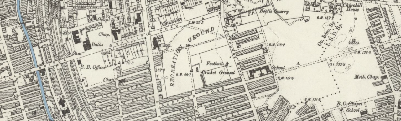
1906/07 survey shows the area completely constructed.
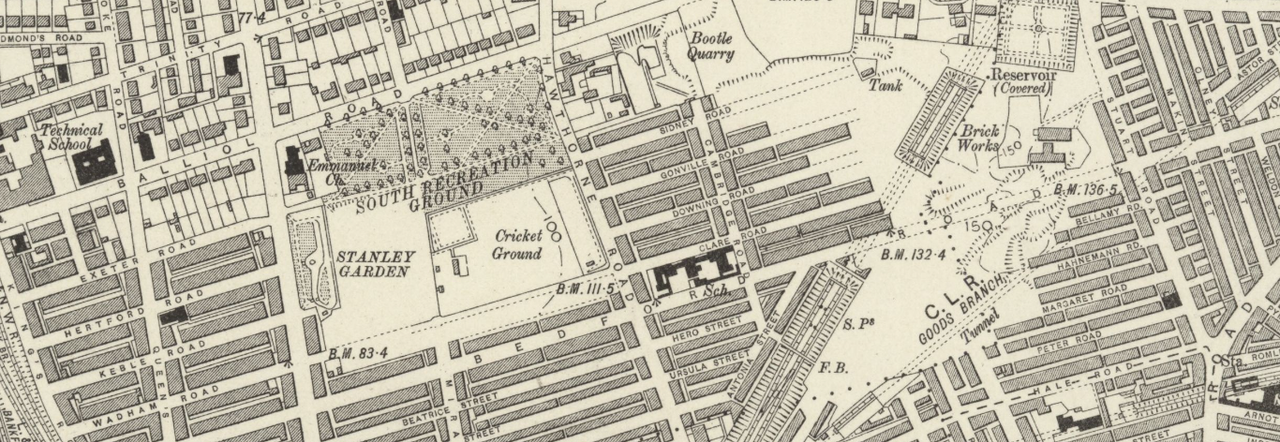
1890 survey shows partial construction of the streets that would stand to the west of the, yet to be constructed, Cambridge Road.
I think it shows that parts of Clare, Downing and Gonville Road had already been built.
The dotted line to the left of the marks BM 118.2 and BM 119.6 indicates the route of the planned Cambridge Road.
The dotted path running off at a right angle marks the future continuation of Bedford Road.
On the basis of this I would say the area was started c1888 and completed by c1892.
1906/07 survey shows the area completely constructed.
-
Charlie Lo
- Posts: 10
- Joined: Thu Nov 19, 2020 8:19 pm
Thanks Dan - great most important fact but snap! I too was born in Gonville road! At # 83 in 1955 so I recon that’s second most imp fact established! 
Thank you for the two maps though comparing google map, 83 seems to be in the not yet built area at the date of 1906 survey. Do you know when the final parts of Gonville were finished.? I’m guessing it might have been 1910/13 which is when, I think, my grandpa moved in. Any ideas about when inside lavvies arrived.
Charlie
Ps what number in Gonville were you born in?
-
BossHogg

- Posts: 572
- Joined: Thu Mar 24, 2016 4:19 am
- Location: Netherton, Maryport.
- Contact:
And me being just a sprog, was born round the corner in Wadham Road in 1967. 


-
Charlie Lo
- Posts: 10
- Joined: Thu Nov 19, 2020 8:19 pm
BossHogg - I remember going down Wadham as a kid in shorts around 1960 on way to Aunties house in Kings Road but there were a couple of ferocious dogs and if they were loose I’d turn around and go down Keble instead. Of course didn’t know names of roads, just knew how to get there. Amazing to think parents would let their four and five year olds wander around streets!
-
Charlie Lo
- Posts: 10
- Joined: Thu Nov 19, 2020 8:19 pm
Hi Bob - thank you for the super helpful directory info. My grandpa and grandma must have moved into 83 in 1914 where they raised their kids. Grandma lived there till 1962!
-
BossHogg
- Posts: 572
- Joined: Thu Mar 24, 2016 4:19 am
- Location: Netherton, Maryport.
- Contact:
Exactly, my parents let us wander far and wide on the estate, just as long as we were home for meal times.Charlie Lo wrote: ↑Tue Jun 15, 2021 9:34 am BossHogg - I remember going down Wadham as a kid in shorts around 1960 on way to Aunties house in Kings Road but there were a couple of ferocious dogs and if they were loose I’d turn around and go down Keble instead. Of course didn’t know names of roads, just knew how to get there. Amazing to think parents would let their four and five year olds wander around streets!
-
Jan
- Posts: 6950
- Joined: Tue Mar 21, 2006 7:34 pm
- Location: Bootle
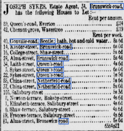
Hi Charlie,
I found this article in The Liverpool Echo 17th October 1893
I will try and find a book that I have , which was published a few years ago called "Bootle Signposts" It names all the streets in Bootle and gives a time-frame of when they were built.
Other articles that I have come across in the past mention Lord Derby as the land owner and he rented houses out on Leasehold for 75 years from 1886. I tried to get the info from knowsley Hall some years ago, but sadly all the papers were not in any particular catalogued order, so the records will remain at Knowsley Hall and are not open for public viewing.
Hope the above helps.
Jan
Old genealogists never die......they just lose their census.
-
Charlie Lo
- Posts: 10
- Joined: Thu Nov 19, 2020 8:19 pm
Thank you Jan - very helpful indeed. From the one listed I see that Gonville Road houses had bath rooms (baths with hot & cold water) so I guess also an inside toilet. All mod cons hence premium rent. My recollection is that there were 2 bedrooms upstairs and 2 living rooms downstairs plus a kitchen and back kitchen/scullery. I don’t think there was a cellar so coal was delivered to shed from the back alley.
-
Dan
- Posts: 4730
- Joined: Sat Jul 07, 2018 6:24 pm
The lowest conversion price of 8/6 in 1893 in today's money is £47.48.
The labour earnings is £196.40.
The relative income value is £348.60.
The relative output value is £663.50.
In 1893, St Helens' general labourers could be paid 16s to 21s per week, with 1s to 3s in stoppages.
The working week would have been 6x10 hour days.
The labour earnings is £196.40.
The relative income value is £348.60.
The relative output value is £663.50.
In 1893, St Helens' general labourers could be paid 16s to 21s per week, with 1s to 3s in stoppages.
The working week would have been 6x10 hour days.
-
Jan
- Posts: 6950
- Joined: Tue Mar 21, 2006 7:34 pm
- Location: Bootle
Charlie,
The streets you have named, they were all built circa 1888 and named after Cambridge colleges.
So more "College" streets in Bootle, similar to the other ones we have like Balliol, Keble, Exeter, Queens, Kings, etc.
Hope that helps again.
Jan
Old genealogists never die......they just lose their census.
-
J.F.G
- Posts: 87
- Joined: Sun Nov 11, 2007 6:21 pm
- Location: Nantwich
Hello Charlie LoCharlie Lo wrote: ↑Wed Jun 16, 2021 2:12 pm Thank you Jan - very helpful indeed. From the one listed I see that Gonville Road houses had bath rooms (baths with hot & cold water) so I guess also an inside toilet. All mod cons hence premium rent. My recollection is that there were 2 bedrooms upstairs and 2 living rooms downstairs plus a kitchen and back kitchen/scullery. I don’t think there was a cellar so coal was delivered to shed from the back alley.
My Nan lived in Longfield Road opposite the Match works, their house was exactly the same layout as you describe, they did have a bathroom but the toilet was still down the yard !
Regards
John
-
Charlie Lo
- Posts: 10
- Joined: Thu Nov 19, 2020 8:19 pm
Dan - thank you for the info with today’s money prices. The rents would have been just affordable to skilled workers like in the directory pages you kindly sent.
Jan - yes, many of the streets around were named after Oxbridge colleges and I wonder if this was some sort of dark humour or education-by-association on the part of property developer (Lord Derby?) or was naming of streets something decided by Bootle Council?
John - after thinking about it, I’m pretty sure that when built the houses would only had an outside toilet because why would the developer ‘waste’ money on two loos. I guess that the inside one would have been added in later years. I do remember using the outside one but hating it because it was dark and probably had spiders under the seat.
Thanks again all
Charlie
-
Bernie R

- Posts: 5650
- Joined: Thu Jan 10, 2008 9:30 am
- Location: Netherton
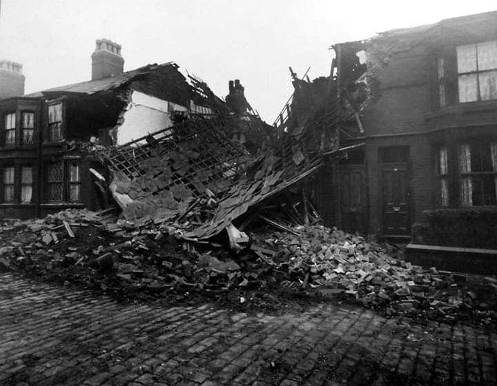
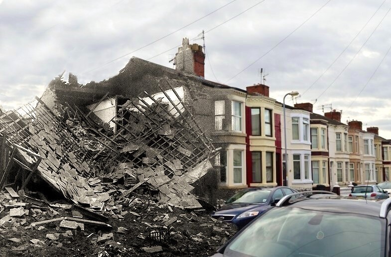
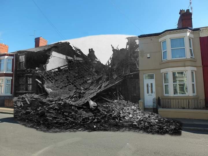
I too am a former Gonville resident - number 62 during the 90s.
Ours was 6 doors down from the one that was bombed in the blitz. Here's a few pics that may interest...
Bern
Ours was 6 doors down from the one that was bombed in the blitz. Here's a few pics that may interest...
Bern
Born and raised in Romeo Street, later Lambeth Walk, Jersey Close, Garden Place, Hawthorne Rd, Gonville Rd now Netherton
-
Charlie Lo
- Posts: 10
- Joined: Thu Nov 19, 2020 8:19 pm
Hi Bernie
Thank you for these pictures - great job of merging the old and new.
Our house was just across the road from the ones pictured and I used to kick about a football onto gable end of the bombed site when I was about 5. I remember my grandma telling me that during the air raids she used to shelter under the stairs which made into a bomb shelter (useless if the bomb had hit). She told me that during one raid - guess it was the one that took out 74 & 76 - she heard the whistle of the bomb across top of her house then the whole place shook. It must have been terrifying. Do you know if anybody died in 74/76?
Quite separately, but in contrast to the air raid defence of my grandma, I visited the small German town of Mannheim about 3 years ago to consult their municipal archives which are in the library part of a converted WW2 bomb shelter. Around 2010 the town council decided to convert the building because it would have been too difficult to demolish. The original bomb shelter structure was huge (like a cube about 30m wide & high) with concrete walls over 2 m thick. It was built to withstand multiple direct hits.The difference in civil defence between what UK did and in Germany is staggering. The municipal archives are stored inside the cube while new offices and library are around the outside and on top. There’s a good image of it on google street view - search Mannheim city archives.
Regards
Charlie
-
Bernie R
- Posts: 5650
- Joined: Thu Jan 10, 2008 9:30 am
- Location: Netherton
Hi Charlie
I can't claim credit for the photo trickery - they're just pics I've harvested over the years as they are of interest to me.
Sorry, I have no details of any casualties in 74/76 being hit but hope all the residents were safely in shelter somewhere.
Bern
I can't claim credit for the photo trickery - they're just pics I've harvested over the years as they are of interest to me.
Sorry, I have no details of any casualties in 74/76 being hit but hope all the residents were safely in shelter somewhere.
Bern
Born and raised in Romeo Street, later Lambeth Walk, Jersey Close, Garden Place, Hawthorne Rd, Gonville Rd now Netherton